
Chapter 15: Thunderstorm Hazards
Alison Nugent and David DeCou
Learning Objectives
By the end of this chapter, you should be able to:
- Identify the different types of precipitation (rain, snow, graupel, hail, etc.)
- Describe how hail forms and why it is difficult to predict
- Summarize how lightning occurs with respect to thunderstorm ice processes
- Discuss the various types of hazards from thunderstorms (gust fronts and outflow winds, precipitation, thunder and lightning, tornadoes)
- Identify radar hook echoes that suggest tornado hazards and discuss the process of warning the public about a tornado threat
Introduction
A thunderstorm is generally defined as any storm that has thunder and lighting. In fact, a climatological thunderstorm day is defined as any day on which thunder is audible from an observing station, and precipitation is not a required element. However, thunderstorms almost always produce precipitation along with the required thunder and lightning, and many other aspects that can be hazardous. Thunderstorms can produce damaging surface winds, hail, heavy rain, and even extreme phenomena like tornadoes. People are often most interested in the damaging aspects of severe weather, as these most directly impact human activity, and often produce beautiful and terrifying visual displays. The hazardous weather associated with thunderstorms will be the topic of this chapter.
Precipitation and Hail
Thunderstorms consist of deep convective clouds that can produce large raindrops (2–8 mm diameter) within 5–10 km wide rain shafts that move horizontally across the ground with precipitation that last from 1–20 minutes over a fixed point. The rainfall rate may be heavy, as much as 10 to 1000 mm of rain per hour. The below photo depicts heavy rain shafts produced by a supercell thunderstorm in Montana.

The cloud tops of thunderstorms extend far up in the troposphere. In the upper parts of the clouds, ice-phase processes occur. Throughout the cloud, different sizes of ice crystals and water droplets exist, and the heavier hydrometeors fall faster than the smaller ones, sometimes colliding and collecting each other. If these heavier ice particles fall through regions of supercooled droplets (liquid water droplets below freezing), they may grow through a process called riming. The liquid water droplets instantly freeze and adhere on contact to the outside surface of falling ice particles. This forms snow pellets called graupel, which are less than 5 mm in diameter. Fallen graupel is pictured below.

Alternatively, smaller ice crystals that fall just below the 0°C level may partially melt and stick to other partially melted ice crystals through collision, causing them to grow through aggregation. These snow aggregates can grow as large as 1 cm in diameter. Snow aggregates and graupel can sometimes reach the ground still frozen or partially frozen, even in the summer, if they fall within cooler, saturated downdrafts. More frequently, these larger ice particles will melt completely into large raindrops before hitting the ground.
Hailstones are irregularly shaped balls of ice larger than 0.5 cm in diameter that are produced in a cumulonimbus cloud—particularly in intense, severe thunderstorms. Hail is formed when graupel or other particles act as embryos that grow through the accretion of supercooled liquid droplets in a cloud. One raindrop takes about one million cloud droplets to form, but a single hailstone may take as many as 10 billion cloud droplets to form. A golf ball-sized hailstone, as pictured below, must travel through the cloud for 5–10 minutes to be able to grow to this size. Strong, violent updrafts within the storm are able to carry smaller ice particles far above the freezing level where collisions with supercooled droplets allow them to grow into hailstones. Rotating updrafts, such as those found in a supercell, are capable of sweeping hail horizontally through the storm, which may allow them to grow much larger. As these growing ice particles pass through areas of the cloud with high liquid water content, extra coatings of ice form around them. Larger hailstones may ascend very slowly in a strong updraft, almost “floating” in place as many supercooled water droplets continue to collide into them. When the hailstone is carried away from the updraft, or if it gets too heavy, it will fall because it is no longer supported by the rising air.
Just below the cloud, the hailstones will begin to melt in the warmer air. Small hail might completely melt before hitting the ground, but in the strong updrafts of severe thunderstorms, hailstones can grow large enough to reach the surface before melting. Notice in the figure below that the hailstone has concentric layers inside, similar to tree rings. The concentric layers alternate clear and opaque ice. This is related to the path that the hailstone takes when it passes through the cloud, as well as the liquid water content of the different areas the hailstone passes through. In areas with low liquid water content (dry growth regime), supercooled water droplets freeze onto the hailstone instantly, which produces the milky opaque ice that contains many air bubbles. In areas with high liquid water content (wet growth regime), supercooled water droplets collect very rapidly onto the hailstone. The transition from liquid to ice releases latent heat, which keeps the surface temperature of the hailstone at 0°C. As a result, supercooled droplets will form a coat of water around the stone rather than freezing instantly. This allows porous areas to be filled in as the water coat freezes slowly and air bubbles escape from the surface. This leaves a layer of clear ice around the hailstone.

Large hail can cause severe damage to crops, vegetation, aircraft, roofs, windows, and create a traffic hazard if hailstones accumulate on a roadway. Damage can be greater if the strong winds in a thunderstorm cause hailstones to move horizontally as they fall. Larger hailstones have higher terminal fall velocities and the potential to reach speeds higher than 50 m·s-1 (112 mph).
Gust Fronts
Gusts fronts were already discussed in the prior chapter, but we’ll include a section here as well. Recall that mature thunderstorms contain both updrafts of warm, buoyant moist air as well as downdrafts of chilled, dry, dense air. Downdrafts are the result of a combination of evaporative cooling, precipitation drag, and dry air entrainment into the cloud. With the onset of precipitation in a mature thunderstorm, there is often a downward rush of cold air. As this cold air hits the surface, it spreads out along the surface in all directions. This surface boundary between the cold horizontally rushing air and the warmer air around it is called the gust front. Along this boundary, winds rapidly change both in direction and speed. The gust front is the leading edge of the outflowing cold air at the surface, and resembles a mini cold front to surface observers. If the gust front of an advancing thunderstorm were to pass by you, you would experience a sharp drop in temperature accompanied by a shift in wind direction and an increase in wind speeds, which may occasionally exceed 55 knots. The air is extremely turbulent along the leading edge of the gust front. As the cold air pushes warm, moist air upward along the boundary, a shelf cloud (or arcus cloud) may form, as shown in the below figure.

When the atmosphere is conditionally unstable, the gust front may produce additional multicell thunderstorms along its leading edge as it forces warm, moist air upward. Each of these additional thunderstorms will each have their own gust front, which may merge together into a large gust front known as an outflow boundary.
Downbursts and Microbursts
Under a severe thunderstorm, the downdraft may become narrow, intense, and localised. As it reaches the surface, it may spread radially along the ground in a burst of wind—similar to water rushing from a faucet and hitting the bottom of the sink. This sort of downdraft is called a downburst. A short downburst, with winds of 4 km or less, is called a microburst. Despite being small spatially, a strong microburst can contain powerful winds up to 146 knots with the capacity to down trees and heavily damage weak structures and boats. Some damage caused by microbursts may have been incorrectly attributed to tornadoes. In addition, wind shear, turbulence, and gusts associated with microbursts have been responsible for several airplane crashes. Microbursts are often associated with severe thunderstorms but have also been known to occur with ordinary cell thunderstorms and even clouds that produce only scattered showers.

Lightning
Lightning is caused by a discharge of electricity that typically occurs in mature thunderstorms. Lightning can strike within the same cloud, from one cloud to another, from a cloud to open air, or from cloud to ground. Only about 20% of lightning strikes are cloud-to-ground (CG) strikes, while the majority of strikes occur within the cloud (CC). As a lightning stroke travels through the atmosphere, it heats the surrounding air to a staggering 30,000°C, which is roughly five times hotter than the surface of the sun. This incredible heating causes a sudden, explosive expansion of the air, generating a shock wave in all directions from the flash. This booms outward in the form of a sound wave called thunder.
Due to the speed that light travels, we see lightning instantly as it happens. Thunder travels much more slowly at about 330 m·s-1 so it takes much longer to reach our ears. You can estimate how distant a lightning stroke is by counting the seconds after you see the flash until you hear the thunder. It takes sound about 5 seconds to travel one mile. If you hear thunder roughly 10 seconds after you see the lightning flash, then the strike occurred about 2 miles away. However, if the lightning is too far, you may not hear any thunder, because sound waves attenuate and bend as they travel through the atmosphere, especially through layers of differing air temperature.

Why do we have lightning? During ordinary fair weather conditions, the earth’s surface has negative charge, while the upper atmosphere is positively charged. Lightning requires differing regions of opposite charge inside a cumulonimbus cloud. There are several theories as to how this separation of charge may come about.
One theory is that clouds can become electrified when graupel and hailstones fall through areas of supercooled droplets, causing the droplets to freeze and release latent heat. This release of latent heat keeps the hailstone surface warmer than the surrounding ice particles. A net transfer of positive ions (molecules that carry a charge) occurs from the warmer hailstone to the colder surrounding ice crystals when they come in contact. Therefore, the larger, warmer hailstone becomes negatively charged and the smaller, cooler ice crystal becomes positively charged. This also happens when supercooled liquid droplets freeze when they come into contact with a warmer hailstone and little fragments of positively charged ice break off. These tiny positively-charged particles are easily swept to the upper regions of the cloud through updrafts. The larger, heavier, negatively-charged hailstones tend to remain suspended at the same level in the updraft or fall to the lower parts of the cloud. This causes the colder upper regions of the cloud to have a net positive charge, while the middle level of the cloud has negative charge. The lowest portion of the cloud generally has a mixture of negative and positive charges, with a positively charged region occasionally present in precipitation bands near the melting level.
In short, thunderstorms must have ice phase processes to produce thunder and lightning—lightning is produced from a discharge of electricity and thunder is simply produced as a result of the lightning.
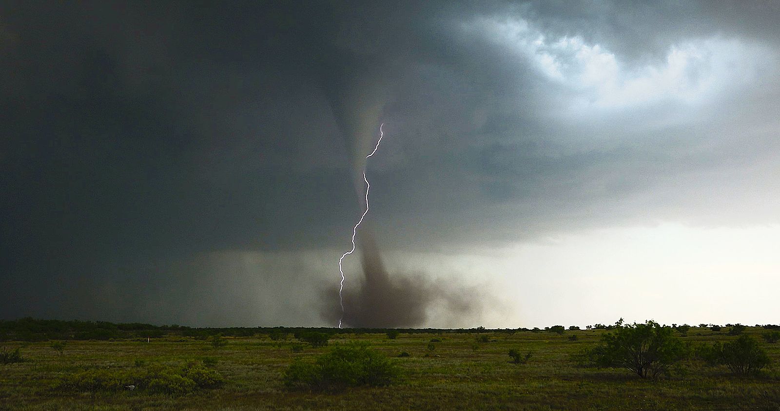
Tornadoes
Recall from the prior chapter that supercell storms can produce tornados. A supercell is a severe thunderstorm with rotation. Typically the rotation of a supercell thunderstorm comes from directional wind shear in the environment. Occasionally a supercell storm produces a tornado, a region of rapidly rotating air in cyclostrophic balance. Recall from Chapter 10 that cyclostrophic balance is a balance between the pressure gradient force and the centrifugal force. As the rotating air motion in a supercell is vertically stretched, it narrows and speeds up. To picture this, imagine a figure skater pulling their arms inward as they spin. Their diameter narrows and their rotation speed increases. The same physics—conservation of angular momentum—occurs as a tornado forms.

Tornados are difficult to forecast well in advance. Typically a Tornado Watch will be issued by a Storm Prediction Center when all of the ingredients for a tornado are present in the atmosphere. These ingredients are the same as for a severe thunderstorm: warm moist air; instability (quantified by large values of CAPE); potential for a trigger; and, of course, directional wind shear to provide rotation. A Tornado Warning is issued when a tornado is imminent or occurring. For example, one may be issued when a funnel cloud is spotted or when a “hook echo” is seen on radar. The issue of forecasting tornados is called “nowcasting”. Although very little advance notice can be given to the public, forecasters do their best to provide as much notice as possible.

The above image shows a hook echo from radar. The key feature is the bottom left region of the storm where a region of rain can be seen rapping around a region of dry inflow air. Right at the cusp of the hook is where a tornado would form if it were occurring. The strong rotation in a tornado creates this radar signature.
Tornado strength is categorized after they occur. A scale called the Enhanced-Fujita scale is used to classify tornado strength based on the amount of damage that was caused. While the wind speed for each step in the EF scale is given, it is not measured. The wind speed is determined afterwards by the scale of damage and the winds required to cause the damage.
| Enhanced Fujita Scale | ||
| Scale | Wind Speed (3 sec. gust, mph) | Damage |
| EF0 | 65-85 | Minor |
| EF1 | 86-110 | Moderate |
| EF2 | 111-135 | Considerable |
| EF3 | 136-165 | Severe |
| EF4 | 166-200 | Extreme |
| EF5 | >200 | Massive/Incredible |
The central US is the world’s hot-spot for tornados, however, tornados and tornado-like storm features can occur elsewhere. A dust devil and a waterspout are tornado-like features that are associated with cumuliform and sometimes cumulonimbus clouds. However, dust devils and waterspouts typically are not associated with a supercell. Waterspouts look like tornados but form over water surfaces. Waterspouts are often narrow, relatively short lived, and formed by the same physics as a tornado—a rotating updraft with condensation in the funnel cloud. Below is an image of a waterspout observed in Hawaii off the coast of Oahu.

Keeping Yourself Safe
From reading this storm hazards chapter, hopefully you’ve learned that severe storms and storm hazards should be taken seriously. Part of the issue with severe weather forecasting is that the impacts are often extremely localized. It is difficult to know if you will be in the exact location that hail will fall or a tornado will pass. Oftentimes, you’ll simply be aware that the possibility is there for storm impacts. Therefore, it is important to take precautions, regardless of whether you are in the right place at the wrong time.
For example, here are a few simple steps you can follow:
- “Turn around, don’t drown” is the saying from the National Weather Service. If you see flowing water over a roadway, don’t drive over it!
- If there is a possibility for thunderstorms, don’t go hiking or do outdoor activities near streams or rivers. Flash flooding is a possibility.
- Similarly, if there is a possibility for thunderstorms, don’t put yourself in an exposed outdoor location. As soon as you hear thunder, a thunderstorm is close enough to be a hazard. Get yourself off of that open sports field, beach, or stadium, and into a shelter until it passes.
- If a tornado is approaching, the safest place is inside the interior room in your house (unless you have a tornado cellar). Get in your closet or your bathtub with a mattress or something to cover you.
Depending on where you live in the world, some hazards are more likely than others. Still, it is important to think in advance about what you would do if you were in a severe storm situation. Oftentimes there isn’t a lot of time to react.
Chapter 15: Questions to Consider
- Why does hail have concentric layers that alternate clear and opaque ice?
-
-
- *FLASH* You saw a lightning stroke! 15 seconds go by… *BOOM* You heard thunder! How far away was the lightning stroke?
-
- Bob just finished reading this chapter and wants to practice sheltering in the event of a tornado warning. Can you help him find the safest place to shelter in his house? (Drag Bob to the correct room.)
Selected Practice Question Answers: